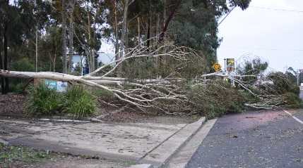
SYDNEY, Aug 3 (NNN-AAP) – Australia’s long stretch of wet and windy weather, showed little signs of easing today, with the punishing conditions continuing throughout much of the nation’s southern regions.
In the Western Australian capital of Perth, departure flights were grounded last night, following a triple storm front, causing power blackouts at the airport and about 35,000 other properties.
Huge surf has already caused erosion along the state’s beaches, which have been hit with waves reaching heights of 10 metres.
Winds of more than 90km/h and squally thunderstorms have been forecast to cross the state’s southern half throughout today, according to the Bureau of Meteorology (BOM).
Meanwhile, on the other side of the nation, Victorian State Emergency Service workers were busy throughout last night, answering more than 200 calls for help after gale-force winds wreaked destruction.
BOM duty forecaster, Phoebe de Wilt, told local newspaper, the Age, that, gusts of more than 100km/h had torn through the state’s alpine peaks and other elevated areas, and predicted more to come as a cold front moves through the region.
In the state of New South Wales (NSW), the BOM warned of thunderstorms bringing up to 35mm of rain tomorrow, in the state’s agricultural Riverina district.
Meteorologist, Dean Narramore, said, a cold front could “tap into some tropical moisture and really bring some moderate to heavy rainfall across parts of Victoria and NSW” and the BOM warns of possible flash flooding, as already overflowing rivers receive yet another drenching.


