SYDNEY, Feb 11 (NNN-AGENCIES) – Multiple bushfires have been raging through vast swathes of Western Australia (WA) throughout this week, while the east of the country has been hit by heavy rains and floods, affected by the La Niña weather pattern.
The fires, which have torn through thousands of hectares of WA bushland and across the state’s wheatbelt, have pushed hundreds of firefighters to the brink of exhaustion.
Until yesterday, the state’s Department of Fire and Emergency Service (DFES) was still issuing extreme fire danger forecasts, for WA’s Great Southern region and a fire ban was declared from today for some local government areas.
The infernos are probably not surprising for many WA residents, who have spent much of the summer sweltering through heat waves, with the capital, Perth, breaking records in Jan, with six consecutive days above 40 degrees Celsius.
The remote coastal town of Onslow, some 1,400 km north of Perth, also equalled the nation’s highest ever temperature of 50.7 degrees Celsius, on Jan 13.
Dr Joe Fontaine from Murdoch University’s Environmental and Conservation Sciences department, said, blazes are often lit deliberately by arsonists or by accident, such as when people let a barbecue get out of control, and a fire will get larger, when the weather is hotter and drier.
He mentioned that, although he thinks this year’s bushfire scale is average, the state would have two more months of bushfire seasons than before, as the fire has come earlier this year.
“We have a Mediterranean climate in WA; it’s wet, but we get almost all of our rain in winter, and our summers are dry,” Fontaine said.
He said that, thunderstorms at this time of year could also spark blazes, when lightning struck parched flora and the rain is few.
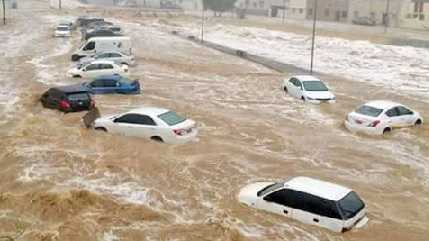
The extreme heat and fires in WA are in stark contrast to the continent’s eastern states, as heavy rains and flooding have washed out parts of New South Wales (NSW), Victoria, and Queensland, since the La Niña weather phenomenon settled in, late last year.
Meteorologist Dr Milton Speer from the University of Technology Sydney (UTS) said, Australia is experiencing intense heat lows over its northwest region “aided by decaying tropical cyclones.”
“Combined with a moist airflow onto the eastern Australian coast, typical of a La Niña, there has been plenty of atmospheric moisture,” Speer said.
However, WA was too far away to benefit from any of this rainy activity and instead faced “persistent northeast to southeast winds directing the hot, dry continental air mass over the west coast.”
Speer also said, the thunderstorm rains that occurred last Nov had been particularly heavy over the nation’s inland regions and had extended further south than normal.
He said, he expected the damp conditions were likely to continue, especially when La Niña reoccurs, and the warming up of the oceans along the northern and eastern coastlines could further add to the cloudy and rainy conditions.
“It is very likely that the extent to which large parts of northern and southeast Australia have had such heavy thunderstorm rain is related to climate change,” Speer said, noting that the trend of increasing temperatures was likely due to global warming.


